iPhone app screenshot Android app screenshot

Overland Navigator

Offroad adventure app for exploring the best New Zealand has to offer.

4WD routes, campsites, interest points and so much more.

Start exploring for free

Hand holding phone

7,900kms+ of amazing routes
all over the country

100s of campsites
across both islands

The latest info from people
driving the routes

Awesome sights and other
interest points to visit

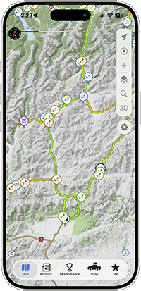
Find your next favourite spot

With an ever-growing list of 4x4 tracks, campsites, and off-the-beaten-path places to explore, Overland Navigator makes it easy to discover new adventures - no matter where you are in Aotearoa.

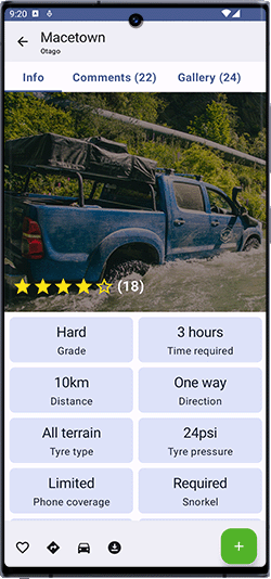
All the details you need

From mellow gravel roads to the more gnarly stuff, every route includes key info, track grades, and what to expect along the way. Take the guesswork out of your trip and explore with confidence.

No complex GPX files or tricky setups

Forget clunky old GPS units, massive downloads, and confusing file imports - Overland Navigator is built to get you exploring straight away. Just download the app, sign up, and you’re ready to go. No setup missions, no fuss.

The latest info from explorers like you

We drive the tracks ourselves - but the best updates come from people out there right now. With real-time comments, photos, and insights from fellow 4WDers, you’ll know exactly what to expect before you go.

Tides
River flows
Latest forecasts
Plan trips with itineraries

Track interest points
Record your own routes
Easy search
DOC land, public access overlays

Popular routes

Sample route

Nevis Valley

Otago

6 hours

66 kilometres

Bush rash

None

Tyre pressures

24psi

Snorkel

Recommended

Cellphone coverage

None

Environment

High country

Surface

Gravel

Up onto the country's highest public road and over the tops, with big panoramic views of the surrounding mountains before you drop into the wide, remote Nevis Valley. It links the Bannockburn/Cromwell end with Garston and Kingston to the south, running through proper high country with hardly anyone around.

Gold mining history is everywhere you look. Old settlements, diggings, a small museum at the old township, and a cemetery sitting in open grassland a few hundred metres off the road. The info boards along the way are worth a read, and folk often stop and yarn with locals at Lower Nevis.

The track is mostly unsealed, a mix of gravel, rocky bits, farm track and several river crossings. Crossings are usually shallow, around 400 to 500mm with hard bottoms and B-line bypasses, though they come up after rain or snowmelt. A high-clearance 4WD is the go. The Queenstown/Garston end is the harder, bumpier half with some tight hilly sections, while the northern end up to the old township is more forgiving.

Duffey's Saddle is a quick detour worth doing for the views, and there's camping and cabins at Kingston. A second person helps with the gates. Closes to vehicles 1 June to 30 September.

Elevation

As rated by 45 explorers like you

Unlock the whole map. Find more tracks, campsites, and adventures with Navigator All Access.

Go further, plan smarter, and discover places most people miss.

Navigator Starter

$0

per month
  • Popular tracks and campsites around New Zealand
  • Keep track of your favourite spots
  • All comments and reviews
  • Unlimited itineraries
  • Full offline support
  • No ads
  • High resolution topo maps
  • Toggle data layers
  • Extra information to help you explore

Navigator All Access

$7.99

per month
  • Tracks and campsites around New Zealand
  • Keep track of your favourite spots
  • All comments and reviews
  • Unlimited itineraries
  • Full offline support
  • No ads
  • High resolution topo maps
  • Toggle data layers
  • Extra information to help you explore

Sign up for a year and get a month free!

Get in touch

Having issues? Track or campsite info not correct? Have a suggestion? We'd love to hear from you!

Contact us